....Celebrates Its 166th Birthday in 2016
"
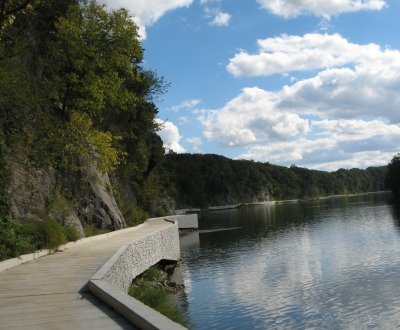
Towpath in the Newly Opened Big Slackwater Area - September 23, 2012
- March 30, 2013 - Volunteers in Parks Page fo rthe Canal
- September 12, 2012 - Page about the Big Slackwater restoration opening ceremony - which will take place October 13.
- November 26 - Interview on WYPR with Justice Douglas' widow and Allen Swope. (first on air in March of 2010)
- March 13 - Website with Info about renting lockhouses
- October 14 - You can listen to a story about Eva the Mule on this page. Real audio file, Windows Media file.
- October 10 - Some lockhouses available for overnight stays
- August 5 - C & WHOA!! Duzer's tale of the C and O
- June 1 - Western Maryland's historical library has a new page about the Canal.
- April 27 - A National Park Service official says $12.1 million in federal funds have been designated to repair a dangerous gap in the Chesapeake and Ohio Canal National Historical Park towpath. Article, including readers' comments from Herald Mail (will only be available for a few days at no charge)
- February 17 - Article about rewatering in Cumberland 2008
- September 14 - The annual River Walk (near Shepherdstown) across the Potomac and then up the towpath can be seen in this YouTube video. Canal for a mile
- April 23 - The Yockatomac Trek is a resource for planning your bike trip from Pittsburgh to Washington.
- April 6 - Captain
Pearl R. Nye: Life on the Ohio and Erie Canal - new online Library
of Congress exhibit.
2006
- October 21 - Added little video about the Antietam Aqueduct
- October 15 John Urman video about the canal
- October 13 Link added to a little video of the path down from the SHepherdstown Bridge to the towpath.
- October 10 - Link added to Catoctin Aqueduct
- April 8 - Potomac Clean-up
- December 16 - The C & O Canal Hits the Coffee Table - story on WAMU about a new book about the canal: The C&O Canal: From Great National Project to National Historical Park (see 5th story on page)
- July 19 - C and O in a day
- June 6 - Afghan Girls Fund Charity Slog - due into DC around June 9 (walking from Frostburg to DC with one teabag...) [PAGE GONE]
- February 15 - Save the C&O Canal a new website - whose mission is to protect the Washington D.C. section of the C&O Canal National Historical Park from private development
- February 9 - Announcement of Canal Awareness Day in Poolesville on May 7.
- January 21 - There's a page starting for GPS coordinates of
points of interest along the canal.
The C & O Canal is a 184 mile long National Historical Park. It begins in Washington, D.C. and follows the Potomac River to Cumberland, Maryland. Construction of the Canal began in on July 4, 1828, the same day the Baltimore and Ohio Railroad was begun. Construction eventually stopped in 1850 when it reached Cumberland. The original idea was for it to go much further west, but the competition from railroads had not been foreseen when the canal was originally planned. It finally began making some profits in the 1870's but at the end of the next decade, a massive flood caused the Canal Company to go into receivership to its rival, the B & O Railroad. The railroad operated the Canal for several decades until another devastating flood in 1924 at which time the Canal was closed for good.In 1938, the 184 mile long stretch of property was acquired by the Federal Government for $2 million and put in the domain of the National Park Service. The Service decided it would make a perfect Parkway - an attractive approach to the city of Washington. However, such was not to be. Justice William Douglas of the Supreme Court reviled the thought of the destruction of the beautiful river corridor. He challenged the editor of the Washington Post, who had come out in favor of the proposed construction, to walk the entire towpath and then decide whether he still thought the road project idea was a good one. The editor agreed to Douglas's proposition, and after completing the hike came out with an editorial in favor of saving the natural beauty of the river and dispensing with the highway. Public opinion turned towards keeping the land natural, and in 1971 it was designated the Chesapeake and Ohio Canal National Historical Park.
Locks and Aqueducts
Other structures that had to be built as a part of the canal were culverts and aqueducts. To enable the canal to cross relatively small streams, over 150 culverts were built. The crossing of major streams required the construction of 11 aqueducts.
One of these, the Monocacy Aqueduct, at mile 42, is thought by many to be the most beautiful feature of the canal. Constructed of pink and white quartz sandstone quarried from the base of nearby Sugarloaf Mountain, the aqueduct withstood Confederate attempts to blow it up during the Civil War. More recently, it suffered extensive damage during 1972's Hurricane Agnes. While it underwent extensive repair work to save it following that flood, it is still in great need of further major repairs if it is to be saved for posterity. A joint campaign to save the Monocacy is in the works.
Cargo and Mules...
The Canal Today

The Canal Towpath is now a very popular spot for walking, biking and horseback riding. And in Georgetown and at Great Falls, you can go for canalboat rides.
For more information, contact:
C & O Canal Headquarters
1850 Dual Highway, Suite 100
Hagerstown, MD 21740
(301) 739-4200Visitors' Centers
Cumberland - (301) 722-8226
Hancock - (301) 678-5463
Williamsport - (301)582-0813
Great Falls - (301) 299-3613
Georgetown - (202) 653-5190
You may also be interested in joining the C and O Canal Association. They publish a quarterly newsletter entitled Along the Towpath. This organization is devoted to the preservation of the Canal and Park. Its members recently donated a new mule named Lil to the Park. You can write to them at:
P.O. Box 366
Glen Echo, Maryland 20812
Or call them at: (301) 983-0825
| Sign Guestbook | View Guestbook |
 |
|
|Here is Volume I of the guestbook. | And the more recent Volume 2 |
Note: This is a different guestbook than the one on the Appalachian Trail page.
| Back to the State-by-State List | Back to the Main A.T. Page |This page was written by Kathy Bilton, Shepherdstown, West Virginia, and was begun in March, 1995. Most recent update: September 2008. The URL: http://www.fred.net/kathy/canal.html

